Overview
Globe Guides and Reports
The Globe User Guides and Reports section contains PDFs that describe relevant scientific background, Getech's methodologies behind Globe's data and analysis tools, user Tips, and any data limitations.
Getech Globe displays several tools that help you get 'closer to the data', i.e. letting you find the data important to you in the shortest amount of time possible.
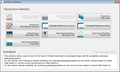
Layer Collections displays an array of options to load sets of layers that fit a particular theme;
it is a great way to get you started with Globe data. It is already symbolised and has been given the appropriate alias names to save you as much time as possible.
You are able to choose from data across multiple timeslices and load all of the data into the same ArcMap session, separating the data into individual data
frames by timeslice. Or you can choose data and constrain them to an area of interest using a specially designed mini-map of the world. Layer Collections
is designed to be used to get data into an MXD with the least fuss possible.
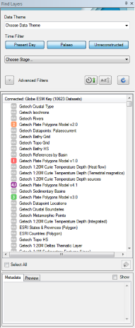
Find Layers is an excellent way to browse through all the Globe data and constrain and filter the data sets using various criteria.
You can then load data quickly and easily into ArcMap.
Numerous functions have been built into the data sets and the toolset to automatically complete the tasks that most users find laborious and time consuming:
- A consistent data set naming convention is applied whenever you add a layer into ArcMap. It is descriptive and informative enough that once you have built your MXD, you and your colleagues will instantly be able to recognise what each layer consists of.
- The correct symbology (as defined by Getech) is automatically applied to a layer for both vector and raster data sets.